Geospatial storytelling for publishers
GEO adds structured spatial context to journalism — transforming place-based coverage into interactive recurring experiences.


Trusted by industry leaders
Loved by leading newsrooms worldwide
Join the ranks of top newsrooms leveraging Timepath to enhance their storytelling and audience engagement.


Stories don’t just unfold over time. They unfold across territory.
Tools built for deep exploration
Don’t just show: engage. Our features are designed to turn passive readers into active participants. Use the bucket list mode to build reader loyalty, or deploy guided tours to provide a seamless narrative flow that keeps your audience on the page longer.
Embed rich media directly into every map pin
With smart markers, you can embed map pins with video, audio, images, and long-form text to create a centralized hub for your reporting. Readers can explore content instantly without ever navigating away from the map. By keeping all assets in one place, you provide a seamless user experience that reduces bounce rates and boosts engagement.
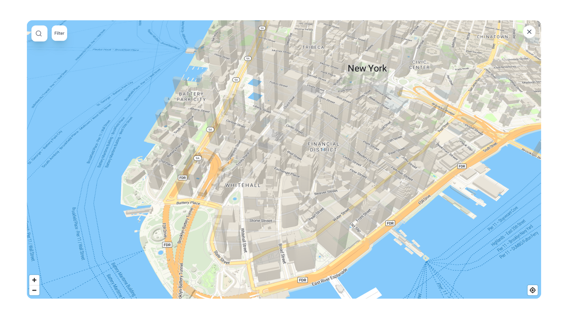
Visualize scale and proximity with zone highlighting
Static pins often fail to capture the full scope of a story. Draw custom shapes to clearly represent neighborhood borders, evacuation zones, or regional districts. This feature provides the visual precision needed to show exactly how much territory a news event covers, moving beyond simple coordinates to show the real-world area of impact.
Toggle map visuals to fit any reporting context
Elevate your reporting by choosing the exact visual layer that supports your narrative, from high-detail satellite imagery to tiltable 3D landscapes. Toggle to a minimalist layer to make election districts pop or utilize 3D street view to show exact vantage points in a crime scene reconstruction. This level of control ensures your maps feel like custom-built editorial assets rather than generic pins, establishing instant authority with your audience.

Empower your audience to explore on their own terms
The overview button provides an organized, chronological directory of every location on your map. By using integrated filters, readers can strip away the clutter to see only the categories they care about, turning a vast data set into a personalized, easy-to-navigate experience.

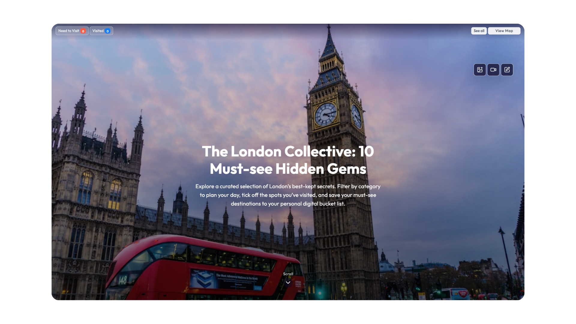
Drive recurring traffic with bucket list mode
Enable readers to "tick off" locations they've visited or would like to go directly within the map. Transform static content into a functional interactive utility that incentivizes repeat visits with fully saved user data for long-term audience investment. Perfect for "Top 10 Hidden Bars" checklists or seasonal festival maps they can explore and complete as they go.

Guide your readers through complex spatial stories
Lead your audience through a curated, step-by-step journey that prioritizes narrative flow over static coordinates. Eliminate reader choice paralysis with cinematic controls that ensure every visitor follows your specific editorial arc from start to finish. Navigate readers through a high-stakes migration route or host a seamless walking tour of a city's cultural landmarks.
GEO brings clarity to complex geographic stories.
From city guides to conflict zones. Tell stories at any scale: whether you are highlighting hidden gems in a local neighborhood or tracking the front lines of an evolving international crisis.
Journalistic:
- Election districts
- Conflict zones
- Climate impact
Use cases
Lifestyle:
- City guides & bucketlists
- Festival maps
- Regional initiatives
Use cases
What chief editors say about Timepath
As the chief editor of RTL Nieuws, I can confidently say that with Timepath liveblogging, we're able to provide real-time updates to our readers as events unfold, keeping them informed and engaged like never before.

Dennis van Luling
Chief Editor, RTL Nieuws
I bristle at using terms like “game changer,” but Timepath is exactly that. We’re a new(ish) platform and looking to separate ourselves from the pack, and the liveblog and collections features give us a clear advantage as we grow. Our use case is simple: ad agency news moves fast and we can’t go in-depth on everything. Our Indie Tracker is a place where we can share important news while giving it depth with the great tools Frido and his team continue to build. Plus, we’ve never worked with people who are so responsive, helpful and willing to work with us like this. If you’re a publisher, this is and easy “yes.” If you’re an agency, there are a lot of ways that you can use this technology to stand out from your competitors with superior curation of your thinking.

Doug Zanger
Editor-in-Chief - Indie Agency News
Timepath has become an essential part of our digital publishing toolkit. It allows our teams to enrich articles with interactive elements in just a few clicks that truly engage our readers. We've seen a clear boost in time spent on page and stronger reader interaction across the board. It's simple to implement, scales well, and fits seamlessly into our editorial workflows.

Han-Menno Depeweg
Chief Technology Officer, Mediahuis

How top newsrooms use Timepath GEO Story
Discover how leading newsrooms use geospatial storytelling to deliver immersive, interactive experiences of complex stories.
Het Parool drives recurring engagement with GEO Story’s bucket list mode
Het Parool transformed their city guides into a high-utility experience featuring 101 must-visit spots across Amsterdam. Integrated filtering for restaurants and landmarks allows readers to navigate the city seamlessly while "ticking off" visited locations or saving future destinations. With fully saved user data and custom social sharing cards, this interactive map converts a static guide into a unique tool that incentivizes repeat visits.

Frequently Asked Questions
From timelines and liveblogs to quizzes, polls, and collections, find answers to the most common questions about creating, customizing, and publishing interactive content with Timepath.
What is Timepath GEO Story?
How can our newsroom use Timepath GEO Story?
How do we embed Timepath GEO Stories, and is it good for SEO?
What are the key benefits of using Timepath GEO Story over standard maps?